Trail Walking Saint-Étienne-de-Tinée - 
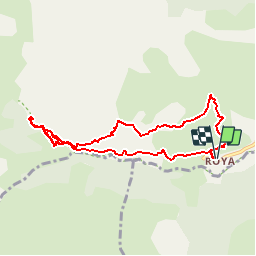
circuit de Baudric, trou des Corneilles  - Photo
 fhascoet
fhascoet

User

© OpenStreetMap contributors
Length
Length
9 km
Max alt
Max alt
1813 m
Uphill gradient
Uphill gradient
514 m
Km-Effort
Km-Effort  
15.8 km
Min alt
Min alt
1513 m
Downhill gradient
Downhill gradient
511 m
Boucle
Boucle
Yes
Creation date :
2017-07-31 00:00:00.0
Updated on :
2017-07-31 00:00:00.0

(0 Reviews)

Walking
Walking
3h28
Difficulty : Medium

Scan this QR Code to open this trail in the SityTrail application

FREE GPS app for hiking

Logo SityTrail SityTrail

IGN / Geographical institutes

Download SityTrail from the App Store Download SityTrail from Google Play

Logo SityTrail SityTrail Plus

The world is yours!

Download SityTrail from the App Store Download SityTrail from Google Play Download SityTrail on Huawei AppGallery

About

Trail Walking of 9 km to be discovered at Provence-Alpes-Côte d'Azur, Maritime Alps, Saint-Étienne-de-Tinée. This trail is proposed by fhascoet.

Description

Belle promenade en Balcon puis montée en passant parle trou des Corneilles ( dessus du Canyon) jusqu’à un accès au torrent.
Après retour au pont, remontée du torrent pour voir l’impressionnante sortie du canyon.

Elevation profile

Photos

Positioning

Country:
France
Region :
Provence-Alpes-Côte d'Azur
Department/Province :
Maritime Alps
Municipality :
Saint-Étienne-de-Tinée
Location:
Unknown
Start:(UTM)
334443 ; 4895014 (32T) N.


Close
My subscriptions