


col de la Golese

mic-13
User
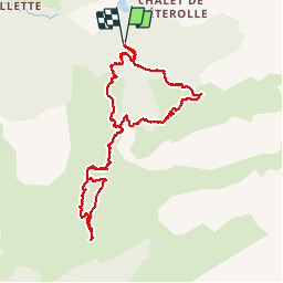

Length
9.7 km

Max alt
1671 m

Uphill gradient
512 m
Km-Effort
16.5 km

Min alt
1317 m

Downhill gradient
511 m
Boucle
Yes
Creation date :
2019-04-23 15:55:43.216
Updated on :
2019-04-23 15:55:43.289
3h48
Difficulty : Easy

FREE GPS app for hiking
 SityTrail
IGN / Geographical institutes
SityTrail Plus
The world is yours!
About
Trail Walking of 9.7 km to be discovered at Auvergne-Rhône-Alpes, Upper Savoy, Samoëns. This trail is proposed by mic-13.


Positioning
Country:
France
Region :
Auvergne-Rhône-Alpes
Department/Province :
Upper Savoy
Municipality :
Samoëns
Location:
Unknown
Start:(Dec)
Start:(UTM)
327522 ; 5112600 (32T) N.
Comments