Trail Walking Gourbit - Gourbit- rochers Carlong - Photo

Gourbit- rochers Carlong

 pidjam
pidjam

User

© OpenStreetMap contributors
Length
Length
11.1 km
Max alt
Max alt
1137 m
Uphill gradient
Uphill gradient
645 m
Km-Effort
Km-Effort  
19.7 km
Min alt
Min alt
639 m
Downhill gradient
Downhill gradient
641 m
Boucle
Boucle
Yes
Creation date :
2017-07-30 00:00:00.0
Updated on :
2017-07-30 00:00:00.0

(0 Reviews)

Walking
Walking
4h15
Difficulty : Medium

Scan this QR Code to open this trail in the SityTrail application

FREE GPS app for hiking

Logo SityTrail SityTrail

IGN / Geographical institutes

Download SityTrail from the App Store Download SityTrail from Google Play

Logo SityTrail SityTrail Plus

The world is yours!

Download SityTrail from the App Store Download SityTrail from Google Play Download SityTrail on Huawei AppGallery

About

Trail Walking of 11.1 km to be discovered at Occitania, Ariège, Gourbit. This trail is proposed by pidjam.

Description

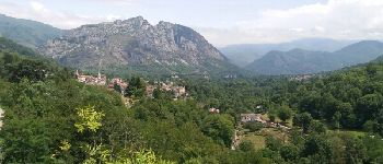
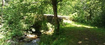
C'est à peu près le même guide que celui de yvessavoy mais avec des corrections nécessaires vu la rando effectuée en juillet 2017. La marche est agréable et souvent dans les bois, la montée est forte (avant la Trajine et jusqu'au GR des 3 seigneurs), le reste passe bien. Il faut se garer à la mairie de Gourbit dès l'entrée du village à gauche(c'est le seul vrai parking et les  rues sont très étroites)

Elevation profile

Photos

Points of interest

Point of interest Rabat-les-Trois-Seigneurs - Panorama sur Rabat 3 seigneurs - Photo
pidjam
RABAT-LES-TROIS-SEIGNEURS 
Point of interest Rabat-les-Trois-Seigneurs - Petit pont - Photo
pidjam
RABAT-LES-TROIS-SEIGNEURS 

Positioning

Country:
France
Region :
Occitania
Department/Province :
Ariège
Municipality :
Gourbit
Location:
Unknown
Start:(UTM)
380280 ; 4744658 (31T) N.


Close
My subscriptions