


Corveissiat Le Mont du Couloir

drarep
User
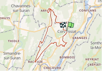

Length
17 km

Max alt
651 m

Uphill gradient
565 m
Km-Effort
25 km

Min alt
424 m

Downhill gradient
564 m
Boucle
Yes
Creation date :
2017-07-31 00:00:00.0
Updated on :
2022-12-15 21:02:12.559
5h35
Difficulty : Very difficult

FREE GPS app for hiking
 SityTrail
IGN / Geographical institutes
SityTrail Plus
The world is yours!
About
Trail Walking of 17 km to be discovered at Auvergne-Rhône-Alpes, Ain, Corveissiat. This trail is proposed by drarep.
Positioning
Country:
France
Region :
Auvergne-Rhône-Alpes
Department/Province :
Ain
Municipality :
Corveissiat
Location:
Unknown
Start:(Dec)
Start:(UTM)
691368 ; 5124147 (31T) N.
Comments