


LACS CAMPO PLANO ET RESPUMOSO

josy31
User
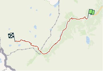

Length
11.4 km

Max alt
2362 m

Uphill gradient
900 m
Km-Effort
21 km

Min alt
1507 m

Downhill gradient
55 m
Boucle
No
Creation date :
2017-07-31 00:00:00.0
Updated on :
2017-07-31 00:00:00.0
8h00
Difficulty : Medium

FREE GPS app for hiking
 SityTrail
IGN / Geographical institutes
SityTrail Plus
The world is yours!
About
Trail Running of 11.4 km to be discovered at Occitania, Hautespyrenees, Cauterets. This trail is proposed by josy31.
Positioning
Country:
France
Region :
Occitania
Department/Province :
Hautespyrenees
Municipality :
Cauterets
Location:
Unknown
Start:(Dec)
Start:(UTM)
733668 ; 4748225 (30T) N.
Comments