


roberval

fitz2014
User

Length
5.6 km

Max alt
124 m

Uphill gradient
91 m
Km-Effort
6.8 km

Min alt
48 m

Downhill gradient
94 m
Boucle
Yes
Creation date :
2017-08-02 00:00:00.0
Updated on :
2017-08-02 00:00:00.0
1h24
Difficulty : Medium

FREE GPS app for hiking
 SityTrail
IGN / Geographical institutes
SityTrail Plus
The world is yours!
About
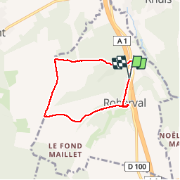
Trail Walking of 5.6 km to be discovered at Hauts-de-France, Oise, Roberval. This trail is proposed by fitz2014.
Positioning
Country:
France
Region :
Hauts-de-France
Department/Province :
Oise
Municipality :
Roberval
Location:
Unknown
Start:(Dec)
Start:(UTM)
477482 ; 5460285 (31U) N.
Comments