col de Tricot

cron
User
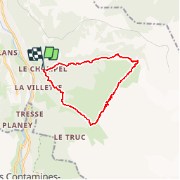

Length
10.9 km

Max alt
2117 m

Uphill gradient
976 m
Km-Effort
24 km

Min alt
1204 m

Downhill gradient
964 m
Boucle
Yes
Creation date :
2017-08-03 00:00:00.0
Updated on :
2017-08-03 00:00:00.0
5h01
Difficulty : Medium

FREE GPS app for hiking
 SityTrail
IGN / Geographical institutes
SityTrail Plus
The world is yours!
About
Trail Walking of 10.9 km to be discovered at Auvergne-Rhône-Alpes, Upper Savoy, Saint-Gervais-les-Bains. This trail is proposed by cron.
Positioning
Country:
France
Region :
Auvergne-Rhône-Alpes
Department/Province :
Upper Savoy
Municipality :
Saint-Gervais-les-Bains
Location:
Unknown
Start:(Dec)
Start:(UTM)
324238 ; 5080968 (32T) N.
Comments