Trail Walking Saint-André-des-Eaux - Sentier Terre Brière - Photo
 phila128
phila128

User

© OpenStreetMap contributors
Length
Length
13.7 km
Max alt
Max alt
19 m
Uphill gradient
Uphill gradient
73 m
Km-Effort
Km-Effort  
14.7 km
Min alt
Min alt
-5 m
Downhill gradient
Downhill gradient
72 m
Boucle
Boucle
Yes
Creation date :
2017-08-14 00:00:00.0
Updated on :
2017-08-14 00:00:00.0

(3 Reviews)

Walking
Walking
3h15
Difficulty : Easy

Scan this QR Code to open this trail in the SityTrail application

FREE GPS app for hiking

Logo SityTrail SityTrail

IGN / Geographical institutes

Download SityTrail from the App Store Download SityTrail from Google Play

Logo SityTrail SityTrail World

The world is yours!

Download SityTrail from the App Store Download SityTrail from Google Play Download SityTrail on Huawei AppGallery

About

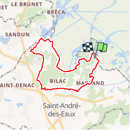
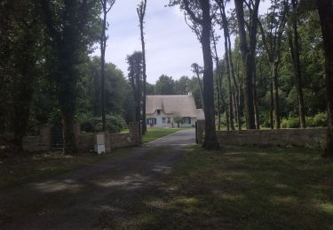
Trail Walking of 13.7 km to be discovered at Pays de la Loire, Loire-Atlantique, Saint-André-des-Eaux. This trail is proposed by phila128.

Description

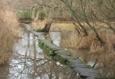
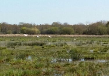
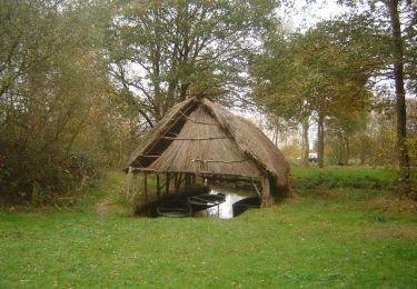
Partez le matin, avant 9h. C’est le moment où la Chaussée Neuve s’éveille, le moment où les promeneurs se préparent et vont chercher leurs chevaux. C’est au galop que les bêtes arrivent du marais, et viennent, prestement, se mettre à l’ouvrage. Un spectacle de toute beauté qui introduit parfaitement la suite : presque sans barrières (ni physique, ni visuelle), le marais indivis est ici un monde tout à fait ouvert, qui n’a que les canaux pour limites. Lorsque le regard se perd au loin, le ciel et la terre se confondent et font de la Brière un univers unique, hors des repères habituels. C’est un lieu où la nature domine, où l’Homme, minoritaire, paraît bien peu de choses, où le contact avec la nature est direct et sans entrave. Un dédale de sentiers souvent ombrés nous offre dès l’abord u

Elevation profile

Positioning

Country:
France
Region :
Pays de la Loire
Department/Province :
Loire-Atlantique
Municipality :
Saint-André-des-Eaux
Location:
Unknown
Start:(UTM)
553852 ; 5243145 (30T) N.

Comments

Please log in to post a review or rate the element


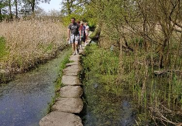
super - super. pas de route. La partie le long du canal est belle. pour le pique-nique 4eme arbre le long du canal, il porte marque GR.


Trails nearby

Trail Walking Saint-Lyphard - boucle chaumières et marais - Photo
Walking
fab0202

Walking

Easy
(1)
Saint-Lyphard, Pays de la Loire, Loire-Atlantique, France
10.7 km | 11.6 km-effort
2h 24min
Yes
Trail Walking Saint-Lyphard - Bréca - Brière sud-ouest - Photo
Walking
gmarboeuf

Walking

Easy
Saint-Lyphard, Pays de la Loire, Loire-Atlantique, France
16.1 km | 17.6 km-effort
3h 53min
Yes
Trail Walking Saint-Lyphard - Port de Bréca - Marais de la Brière - Photo
Walking
tracegps

Walking

Easy
(2)
Saint-Lyphard, Pays de la Loire, Loire-Atlantique, France
5.2 km | 5.6 km-effort
1h 30min
Yes
Trail Walking Saint-Lyphard - 2023-07-29 Brèca -st lyphar - Photo
Walking
jacq58

Walking

Medium
Saint-Lyphard, Pays de la Loire, Loire-Atlantique, France
16.5 km | 18 km-effort
3h 32min
Yes
Trail Walking Saint-Lyphard - SAINT-LYPHARD_01_KERHINET_L'EGUIGNAC_20180422 - Photo
Walking
patrickdanilo

Walking

Very easy
Saint-Lyphard, Pays de la Loire, Loire-Atlantique, France
12 km | 13.1 km-effort
2h 53min
Yes
Trail Walking Saint-André-des-Eaux - trehe - Photo
Walking
quitou

Walking

Medium
Saint-André-des-Eaux, Pays de la Loire, Loire-Atlantique, France
7.3 km | 8.2 km-effort
1h 41min
Yes
Trail Hybrid bike Saint-André-des-Eaux - saint André  - Photo
Hybrid bike
Jean-claude Ainé

Hybrid bike

Easy
Saint-André-des-Eaux, Pays de la Loire, Loire-Atlantique, France
9.3 km | 10.1 km-effort
50min
No
Trail Walking Saint-André-des-Eaux - boucle de Tréhé - Photo
Walking
clguez

Walking

Easy
Saint-André-des-Eaux, Pays de la Loire, Loire-Atlantique, France
4 km | 4.2 km-effort
1h 19min
Yes
Trail Walking Saint-Lyphard - marais briere - Photo
Walking
micksop

Walking

Easy
Saint-Lyphard, Pays de la Loire, Loire-Atlantique, France
5.5 km | 5.9 km-effort
1h 54min
Yes


Close
My subscriptions