


Marche du 14082017

fabwin
User GUIDE
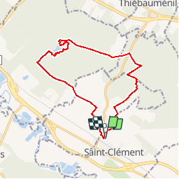

Length
14.1 km

Max alt
280 m

Uphill gradient
97 m
Km-Effort
15.4 km

Min alt
240 m

Downhill gradient
97 m
Boucle
Yes
Creation date :
2018-04-16 20:50:09.609
Updated on :
2018-04-16 20:50:09.609
3h00
Difficulty : Very easy

FREE GPS app for hiking
 SityTrail
IGN / Geographical institutes
SityTrail Plus
The world is yours!
About
Trail Walking of 14.1 km to be discovered at Grand Est, Meurthe-et-Moselle, Saint-Clément. This trail is proposed by fabwin.
Description
Soleil et chaleur.
Marche agrémentée de petit footing pour essayer, et ma foi, ca va!!
Positioning
Country:
France
Region :
Grand Est
Department/Province :
Meurthe-et-Moselle
Municipality :
Saint-Clément
Location:
Unknown
Start:(Dec)
Start:(UTM)
323057 ; 5378579 (32U) N.
Comments