


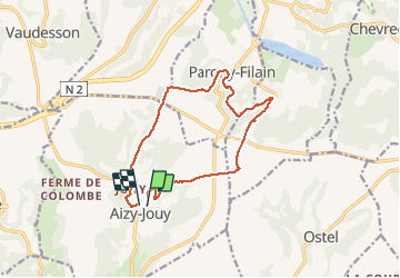
l assaut du chemin des dames

hm
User

Length
12.4 km

Max alt
191 m

Uphill gradient
241 m
Km-Effort
15.7 km

Min alt
82 m

Downhill gradient
250 m
Boucle
Yes
Creation date :
2017-08-15 00:00:00.0
Updated on :
2017-08-15 00:00:00.0
2h53
Difficulty : Medium

FREE GPS app for hiking
 SityTrail
IGN / Geographical institutes
SityTrail Plus
The world is yours!
About
Trail Walking of 12.4 km to be discovered at Hauts-de-France, Aisne, Aizy-Jouy. This trail is proposed by hm.
Photos


Positioning
Country:
France
Region :
Hauts-de-France
Department/Province :
Aisne
Municipality :
Aizy-Jouy
Location:
Unknown
Start:(Dec)
Start:(UTM)
537505 ; 5476051 (31U) N.
Comments