


15.08.2017 - PORT ST HUBERT à TADEN

babeth35
User
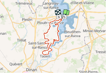

Length
28 km

Max alt
78 m

Uphill gradient
427 m
Km-Effort
34 km

Min alt
3 m

Downhill gradient
432 m
Boucle
Yes
Creation date :
2017-08-15 00:00:00.0
Updated on :
2020-07-20 15:12:56.952
7h20
Difficulty : Medium

FREE GPS app for hiking
 SityTrail
IGN / Geographical institutes
SityTrail Plus
The world is yours!
About
Trail Walking of 28 km to be discovered at Brittany, Côtes-d'Armor, Plouër-sur-Rance. This trail is proposed by babeth35.
Positioning
Country:
France
Region :
Brittany
Department/Province :
Côtes-d'Armor
Municipality :
Plouër-sur-Rance
Location:
Unknown
Start:(Dec)
Start:(UTM)
575639 ; 5376111 (30U) N.
Comments