


Chesery_le Reculet D+ 1304 21.3 km 20170813

cmike39
User
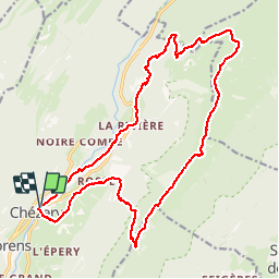

Length
21 km

Max alt
1699 m

Uphill gradient
1340 m
Km-Effort
39 km

Min alt
585 m

Downhill gradient
1340 m
Boucle
Yes
Creation date :
2017-08-18 00:00:00.0
Updated on :
2017-08-18 00:00:00.0
7h55
Difficulty : Unknown

FREE GPS app for hiking
 SityTrail
IGN / Geographical institutes
SityTrail Plus
The world is yours!
About
Trail Walking of 21 km to be discovered at Auvergne-Rhône-Alpes, Ain, Chézery-Forens. This trail is proposed by cmike39.
Positioning
Country:
France
Region :
Auvergne-Rhône-Alpes
Department/Province :
Ain
Municipality :
Chézery-Forens
Location:
Unknown
Start:(Dec)
Start:(UTM)
721191 ; 5122850 (31T) N.
Comments