Trail Cycle Champignelles - vacances 2017 Breves - Photo
© OpenStreetMap contributors
Length
Length
76 km
Max alt
Max alt
323 m
Uphill gradient
Uphill gradient
711 m
Km-Effort
Km-Effort  
86 km
Min alt
Min alt
141 m
Downhill gradient
Downhill gradient
735 m
Boucle
Boucle
No
Creation date :
2017-08-17 00:00:00.0
Updated on :
2017-08-17 00:00:00.0

(0 Reviews)

Cycle
Cycle
4h52
Difficulty : Easy

Scan this QR Code to open this trail in the SityTrail application

FREE GPS app for hiking

Logo SityTrail SityTrail

IGN / Geographical institutes

Download SityTrail from the App Store Download SityTrail from Google Play

Logo SityTrail SityTrail World

The world is yours!

Download SityTrail from the App Store Download SityTrail from Google Play Download SityTrail on Huawei AppGallery

About

Trail Cycle of 76 km to be discovered at Bourgogne-Franche-Comté, Yonne, Champignelles. This trail is proposed by Moonslepaysans.

Description

départ 10hr30
arrivée 19hr

Elevation profile

Positioning

Country:
France
Region :
Bourgogne-Franche-Comté
Department/Province :
Yonne
Municipality :
Champignelles
Location:
Unknown
Start:(UTM)
507560 ; 5292558 (31T) N.

Trails nearby

Trail Walking Charny Orée de Puisaye - Grandchamp - Photo
Walking
pikibangi

Walking

Difficult
Charny Orée de Puisaye, Bourgogne-Franche-Comté, Yonne, France
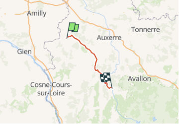
13.3 km | 15.2 km-effort
2h 55min
Yes
Trail Walking Charny Orée de Puisaye - Malicorne 89 23km - Photo
Walking
picouleau220345

Walking

Medium
Charny Orée de Puisaye, Bourgogne-Franche-Comté, Yonne, France
23 km | 27 km-effort
4h 33min
Yes
Trail Equestrian Charny Orée de Puisaye - Géro.Etape4 - Photo
Equestrian
aucamus

Equestrian

Very easy
Charny Orée de Puisaye, Bourgogne-Franche-Comté, Yonne, France
24 km | 27 km-effort
5h 0min
No


Close
My subscriptions