


Peyre Martine par le Roc du Caylaret

ARVIEU
User

Length
15.8 km

Max alt
772 m

Uphill gradient
880 m
Km-Effort
28 km

Min alt
157 m

Downhill gradient
881 m
Boucle
Yes
Creation date :
2017-08-20 00:00:00.0
Updated on :
2017-08-20 00:00:00.0
6h00
Difficulty : Medium

FREE GPS app for hiking
 SityTrail
IGN / Geographical institutes
SityTrail Plus
The world is yours!
About
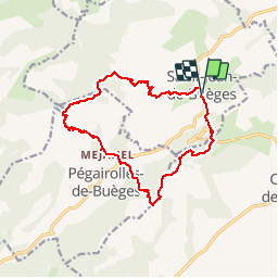
Trail Walking of 15.8 km to be discovered at Occitania, Hérault, Saint-Jean-de-Buèges. This trail is proposed by ARVIEU.
Description
Peyre Martine par le Roc du Caylaret, retour par le Saut des Coffres
Positioning
Country:
France
Region :
Occitania
Department/Province :
Hérault
Municipality :
Saint-Jean-de-Buèges
Location:
Unknown
Start:(Dec)
Start:(UTM)
549680 ; 4852793 (31T) N.
Comments
tracastel