


ALBARET 61 km VTT Faverolles

benoit48
User
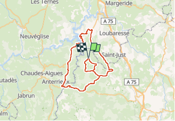

Length
62 km

Max alt
1133 m

Uphill gradient
1069 m
Km-Effort
76 km

Min alt
734 m

Downhill gradient
1068 m
Boucle
Yes
Creation date :
2018-01-06 00:00:00.0
Updated on :
2018-01-06 00:00:00.0
4h13
Difficulty : Unknown

FREE GPS app for hiking
 SityTrail
IGN / Geographical institutes
SityTrail Plus
The world is yours!
About
Trail Cycle of 62 km to be discovered at Occitania, Lozère, Albaret-le-Comtal. This trail is proposed by benoit48.
Positioning
Country:
France
Region :
Occitania
Department/Province :
Lozère
Municipality :
Albaret-le-Comtal
Location:
Unknown
Start:(Dec)
Start:(UTM)
510867 ; 4969990 (31T) N.
Comments