


L'Escalet-Cap Taillat 01

dufland
User
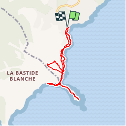

Length
7.2 km

Max alt
107 m

Uphill gradient
211 m
Km-Effort
10 km

Min alt
0 m

Downhill gradient
209 m
Boucle
Yes
Creation date :
2019-04-16 12:59:13.728
Updated on :
2019-04-16 12:59:13.758
3h00
Difficulty : Medium

FREE GPS app for hiking
 SityTrail
IGN / Geographical institutes
SityTrail Plus
The world is yours!
About
Trail Walking of 7.2 km to be discovered at Provence-Alpes-Côte d'Azur, Var, Ramatuelle. This trail is proposed by dufland.
Positioning
Country:
France
Region :
Provence-Alpes-Côte d'Azur
Department/Province :
Var
Municipality :
Ramatuelle
Location:
Unknown
Start:(Dec)
Start:(UTM)
308363 ; 4784327 (32T) N.
Comments