


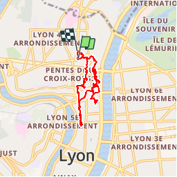
Lyon-Croix-Rousse

m261212
User

Length
8.5 km

Max alt
254 m

Uphill gradient
159 m
Km-Effort
10.6 km

Min alt
174 m

Downhill gradient
161 m
Boucle
Yes
Creation date :
2017-08-21 00:00:00.0
Updated on :
2017-08-21 00:00:00.0
3h14
Difficulty : Unknown

FREE GPS app for hiking
 SityTrail
IGN / Geographical institutes
SityTrail Plus
The world is yours!
About
Trail Walking of 8.5 km to be discovered at Auvergne-Rhône-Alpes, Métropole de Lyon, Lyon. This trail is proposed by m261212.
Positioning
Country:
France
Region :
Auvergne-Rhône-Alpes
Department/Province :
Métropole de Lyon
Municipality :
Lyon
Location:
Lyon 4e Arrondissement
Start:(Dec)
Start:(UTM)
642470 ; 5070625 (31T) N.
Comments
Montrichard 20 km