Trail Walking Saurier - 
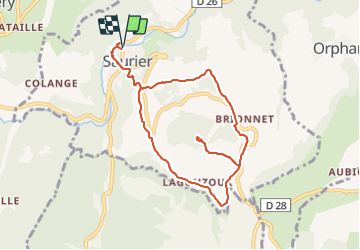
Saurier_Pic_de_Brionnet - Photo
 jagarnier
jagarnier

User GUIDE

© OpenStreetMap contributors
Length
Length
9.1 km
Max alt
Max alt
905 m
Uphill gradient
Uphill gradient
355 m
Km-Effort
Km-Effort  
13.8 km
Min alt
Min alt
551 m
Downhill gradient
Downhill gradient
354 m
Boucle
Boucle
Yes
Creation date :
2017-08-22 00:00:00.0
Updated on :
2025-04-27 07:36:46.237

(1 Reviews)

Walking
Walking
2h45
Difficulty : Medium

Scan this QR Code to open this trail in the SityTrail application

FREE GPS app for hiking

Logo SityTrail SityTrail

IGN / Geographical institutes

Download SityTrail from the App Store Download SityTrail from Google Play

Logo SityTrail SityTrail Plus

The world is yours!

Download SityTrail from the App Store Download SityTrail from Google Play Download SityTrail on Huawei AppGallery

About

Trail Walking of 9.1 km to be discovered at Auvergne-Rhône-Alpes, Puy-de-Dôme, Saurier. This trail is proposed by jagarnier.

Description

La montée au pic de Brionnet (927 m) offre aux randonneurs une vue panoramique sur les Couzes, le massif du Puy de Dôme et l'accès à une chapelle romane construite sur des orgues basaltiques. Vous découvrirez aussi Saurier, ancien village fortifié entouré de ses vieux vergers de pommiers.

Elevation profile

Photos

Positioning

Country:
France
Region :
Auvergne-Rhône-Alpes
Department/Province :
Puy-de-Dôme
Municipality :
Saurier
Location:
Unknown
Start:(UTM)
503560 ; 5042890 (31T) N.

Comments

Please log in to post a review or rate the element


très belle randonnée


Close
My subscriptions