Trail Cycle Nyon - Nyon - Lignerolle - Photo

Nyon - Lignerolle

© OpenStreetMap contributors
Length
Length
69 km
Max alt
Max alt
1364 m
Uphill gradient
Uphill gradient
1594 m
Km-Effort
Km-Effort  
89 km
Min alt
Min alt
424 m
Downhill gradient
Downhill gradient
1257 m
Boucle
Boucle
No
Creation date :
2017-08-31 00:00:00.0
Updated on :
2017-08-31 00:00:00.0

(0 Reviews)

Cycle
Cycle
4h58
Difficulty : Very difficult

Scan this QR Code to open this trail in the SityTrail application

FREE GPS app for hiking

Logo SityTrail SityTrail

IGN / Geographical institutes

Download SityTrail from the App Store Download SityTrail from Google Play

Logo SityTrail SityTrail World

The world is yours!

Download SityTrail from the App Store Download SityTrail from Google Play Download SityTrail on Huawei AppGallery

About

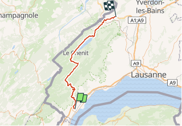
Trail Cycle of 69 km to be discovered at Vaud, District de Nyon, Nyon. This trail is proposed by karawatsj.

Description

Prachtige tocht door de rustige haast verlaten Combe des Amburnex met zicht op de Mont Blanc. Daarna geleidelijke afdaling langs de oevers van Lac du Joux tot in het toeristische Le Pont.
Vervolgens een steile onverwachte klim en dan een afdaling over onverharde weg (eerder voor mountain-bike) tot in Vallorbe.
Opnieuw een flinke klim tot over de autostrade en een afdaling naar Lignerolle. Opnieuw zicht op de besneeuwde alpentoppen.
Stuk van de Juraroute nr 7

Elevation profile

Photos

Positioning

Country:
Switzerland
Region :
Vaud
Department/Province :
District de Nyon
Municipality :
Nyon
Location:
Unknown
Start:(UTM)
287166 ; 5141375 (32T) N.

Trails nearby

Trail Walking Nyon - w_CHpur05_toblerone - Photo
Walking
GUIDE+

Walking

Very easy
(1)
Nyon, Vaud, District de Nyon, Switzerland
16.1 km | 21 km-effort
Unknown
No
Trail Cycle Prangins - ST_par_typ_2 - Photo
Cycle
GUIDE+

Cycle

Very easy
Prangins, Vaud, District de Nyon, Switzerland
281 km | 403 km-effort
4h 47min
No
Trail Cycle Nyon - ST_par_typ_hot09 - Photo
Cycle
GUIDE+

Cycle

Very easy
(1)
Nyon, Vaud, District de Nyon, Switzerland
278 km | 375 km-effort
6h 26min
No
Trail Walking Nyon - st_ral_08_2 - Photo
Walking
GUIDE+

Walking

Very easy
Nyon, Vaud, District de Nyon, Switzerland
36 km | 41 km-effort
1h 21min
No
Trail Mountain bike Chéserex - dole - Photo
Mountain bike
ropo

Mountain bike

Very easy
Chéserex, Vaud, District de Nyon, Switzerland
63 km | 83 km-effort
2h 40min
No
Trail Walking Vich - Sentier des Toblerones - Photo
Walking
hgauchat

Walking

Easy
Vich, Vaud, District de Nyon, Switzerland
9.5 km | 11.7 km-effort
2h 56min
No
Trail Other activity Chéserex - Cheserex - St Cergues - Photo
Other activity
anselmo

Other activity

Very easy
Chéserex, Vaud, District de Nyon, Switzerland
66 km | 90 km-effort
Unknown
Yes
Trail Other activity Chéserex - barillette - Photo
Other activity
anselmo

Other activity

Very easy
Chéserex, Vaud, District de Nyon, Switzerland
9.8 km | 19.3 km-effort
Unknown
No
Trail Other activity Crans (VD) - Region Nyon - Photo
Other activity
gberweil

Other activity

Very easy
Crans (VD), Vaud, District de Nyon, Switzerland
27 km | 33 km-effort
Unknown
Yes


Close
My subscriptions