


Gramat vers Rocamadour

choubaka77
User
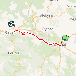

Length
11.6 km

Max alt
321 m

Uphill gradient
272 m
Km-Effort
15.7 km

Min alt
138 m

Downhill gradient
407 m
Boucle
No
Creation date :
2018-04-16 21:37:41.521
Updated on :
2018-04-16 21:37:41.521
3h34
Difficulty : Easy

FREE GPS app for hiking
 SityTrail
IGN / Geographical institutes
SityTrail Plus
The world is yours!
About
Trail Walking of 11.6 km to be discovered at Occitania, Lot, Gramat. This trail is proposed by choubaka77.
Description
Étape courte et agréable. Arrivé en tout début d'après midi, cela laisse le temps de découvrir Rocamadour après être passé en fond de canyon pour découvrir les restes de vieux moulins à eau.
Photos


Positioning
Country:
France
Region :
Occitania
Department/Province :
Lot
Municipality :
Gramat
Location:
Unknown
Start:(Dec)
Start:(UTM)
399211 ; 4959249 (31T) N.
Comments