


Ayydat

JeanPierreNancy
User
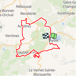

Length
37 km

Max alt
1180 m

Uphill gradient
611 m
Km-Effort
45 km

Min alt
923 m

Downhill gradient
607 m
Boucle
Yes
Creation date :
2018-04-16 21:41:53.3
Updated on :
2019-07-12 16:12:09.649
3h18
Difficulty : Unknown

FREE GPS app for hiking
 SityTrail
IGN / Geographical institutes
SityTrail Plus
The world is yours!
About
Trail Mountain bike of 37 km to be discovered at Auvergne-Rhône-Alpes, Puy-de-Dôme, Aydat. This trail is proposed by JeanPierreNancy.
Positioning
Country:
France
Region :
Auvergne-Rhône-Alpes
Department/Province :
Puy-de-Dôme
Municipality :
Aydat
Location:
Unknown
Start:(Dec)
Start:(UTM)
497349 ; 5055991 (31T) N.
Comments