


forêt de la Joux

Ajax44
User
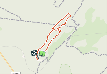

Length
7.1 km

Max alt
900 m

Uphill gradient
252 m
Km-Effort
10.4 km

Min alt
731 m

Downhill gradient
248 m
Boucle
Yes
Creation date :
2017-08-27 00:00:00.0
Updated on :
2017-08-27 00:00:00.0
2h10
Difficulty : Medium

FREE GPS app for hiking
 SityTrail
IGN / Geographical institutes
SityTrail Plus
The world is yours!
About
Trail Walking of 7.1 km to be discovered at Bourgogne-Franche-Comté, Jura, Supt. This trail is proposed by Ajax44.
Positioning
Country:
France
Region :
Bourgogne-Franche-Comté
Department/Province :
Jura
Municipality :
Supt
Location:
Unknown
Start:(Dec)
Start:(UTM)
271768 ; 5192539 (32T) N.
Comments