


170829 Franiere 11 kms

DANIELVGL
User
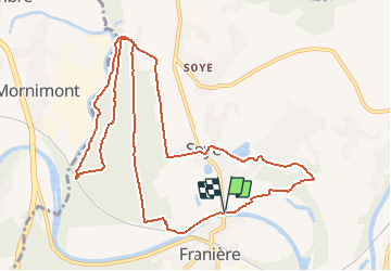

Length
11.6 km

Max alt
130 m

Uphill gradient
163 m
Km-Effort
13.8 km

Min alt
81 m

Downhill gradient
162 m
Boucle
Yes
Creation date :
2017-08-29 00:00:00.0
Updated on :
2017-08-29 00:00:00.0
1h30
Difficulty : Medium

FREE GPS app for hiking
 SityTrail
IGN / Geographical institutes
SityTrail Plus
The world is yours!
About
Trail Running of 11.6 km to be discovered at Wallonia, Namur, Floreffe. This trail is proposed by DANIELVGL.
Positioning
Country:
Belgium
Region :
Wallonia
Department/Province :
Namur
Municipality :
Floreffe
Location:
Soye
Start:(Dec)
Start:(UTM)
623141 ; 5589352 (31U) N.
Comments