


Régusse N/O

Sugg
User
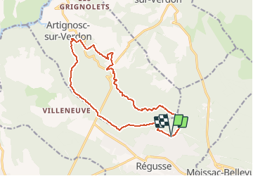

Length
16.3 km

Max alt
596 m

Uphill gradient
246 m
Km-Effort
19.6 km

Min alt
449 m

Downhill gradient
246 m
Boucle
Yes
Creation date :
2019-03-22 16:58:18.12
Updated on :
2019-03-22 16:58:18.166
5h00
Difficulty : Easy

FREE GPS app for hiking
 SityTrail
IGN / Geographical institutes
SityTrail Plus
The world is yours!
About
Trail Walking of 16.3 km to be discovered at Provence-Alpes-Côte d'Azur, Var, Régusse. This trail is proposed by Sugg.
Description
Bois des Collocations
Parcours à reconnaître pour le 22-11-17.
Positioning
Country:
France
Region :
Provence-Alpes-Côte d'Azur
Department/Province :
Var
Municipality :
Régusse
Location:
Unknown
Start:(Dec)
Start:(UTM)
269512 ; 4838698 (32T) N.
Comments