


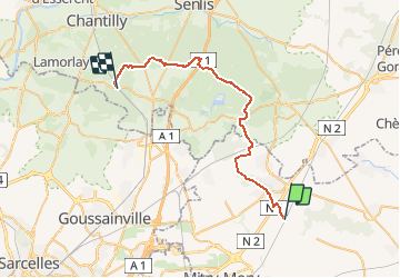
Saint Mard coye la foret par la foret d Ermenonville

meillon
User

Length
34 km

Max alt
171 m

Uphill gradient
379 m
Km-Effort
39 km

Min alt
49 m

Downhill gradient
402 m
Boucle
No
Creation date :
2017-08-30 00:00:00.0
Updated on :
2017-08-30 00:00:00.0
10h00
Difficulty : Difficult

FREE GPS app for hiking
 SityTrail
IGN / Geographical institutes
SityTrail Plus
The world is yours!
About
Trail Other activity of 34 km to be discovered at Ile-de-France, Seine-et-Marne, Saint-Mard. This trail is proposed by meillon.
Description
A travers val, prairies champs et forets
Positioning
Country:
France
Region :
Ile-de-France
Department/Province :
Seine-et-Marne
Municipality :
Saint-Mard
Location:
Unknown
Start:(Dec)
Start:(UTM)
477875 ; 5431009 (31U) N.
Comments