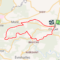
Trail Walking Assesse - Crupet en sous bois - Photo

Crupet en sous bois

 mozzipsc
mozzipsc

User

© OpenStreetMap contributors
Length
Length
14.6 km
Max alt
Max alt
288 m
Uphill gradient
Uphill gradient
418 m
Km-Effort
Km-Effort  
20 km
Min alt
Min alt
116 m
Downhill gradient
Downhill gradient
414 m
Boucle
Boucle
Yes
Creation date :
2017-08-30 00:00:00.0
Updated on :
2017-08-30 00:00:00.0

(0 Reviews)

Walking
Walking
4h00
Difficulty : Medium

Scan this QR Code to open this trail in the SityTrail application

FREE GPS app for hiking

Logo SityTrail SityTrail

IGN / Geographical institutes

Download SityTrail from the App Store Download SityTrail from Google Play

Logo SityTrail SityTrail Plus

The world is yours!

Download SityTrail from the App Store Download SityTrail from Google Play Download SityTrail on Huawei AppGallery

About

Trail Walking of 14.6 km to be discovered at Wallonia, Namur, Assesse. This trail is proposed by mozzipsc.

Description

Joli parcours pour la plupart en sous bois, allonge  bois et forêt domaniale, n'hésitez pas a passer les indications de bois 'privé'
beau panorama, une seule grosse difficulté au pied du bock, montée de 110m sur terrain peu pratiqué. Le reste nickel :-)

Elevation profile

Positioning

Country:
Belgium
Region :
Wallonia
Department/Province :
Namur
Municipality :
Assesse
Location:
Crupet
Start:(UTM)
639494 ; 5579204 (31U) N.


Close
My subscriptions