


Bondoufle-Yevre le Chatel A/R

Lucquiaud
User
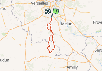

Length
134 km

Max alt
149 m

Uphill gradient
1083 m
Km-Effort
149 km

Min alt
53 m

Downhill gradient
1082 m
Boucle
Yes
Creation date :
2018-09-15 15:03:24.739
Updated on :
2020-12-24 15:38:31.967
8h24
Difficulty : Medium

FREE GPS app for hiking
 SityTrail
IGN / Geographical institutes
SityTrail Plus
The world is yours!
About
Trail Cycle of 134 km to be discovered at Ile-de-France, Essonne, Bondoufle. This trail is proposed by Lucquiaud.
Description
circuit pur aller visiter l'un des plus beaux villages de France
Positioning
Country:
France
Region :
Ile-de-France
Department/Province :
Essonne
Municipality :
Bondoufle
Location:
Unknown
Start:(Dec)
Start:(UTM)
454093 ; 5384709 (31U) N.
Comments