


plateau lisey 2017

cemoi
User
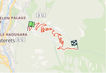

Length
4.1 km

Max alt
1618 m

Uphill gradient
570 m
Km-Effort
9.8 km

Min alt
1041 m

Downhill gradient
6 m
Boucle
No
Creation date :
2019-06-18 08:26:42.374
Updated on :
2020-04-24 08:02:00.235
2h21
Difficulty : Easy

FREE GPS app for hiking
 SityTrail
IGN / Geographical institutes
SityTrail Plus
The world is yours!
About
Trail Walking of 4.1 km to be discovered at Occitania, Hautespyrenees, Cauterets. This trail is proposed by cemoi.
Positioning
Country:
France
Region :
Occitania
Department/Province :
Hautespyrenees
Municipality :
Cauterets
Location:
Unknown
Start:(Dec)
Start:(UTM)
736194 ; 4752816 (30T) N.
Comments