


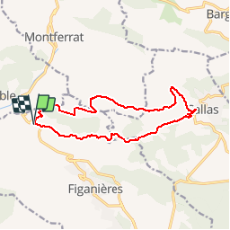
Montferrat-Bois de la Cabre d'or

Sugg
User

Length
14.7 km

Max alt
702 m

Uphill gradient
479 m
Km-Effort
21 km

Min alt
358 m

Downhill gradient
479 m
Boucle
Yes
Creation date :
2019-03-22 16:58:17.738
Updated on :
2019-03-22 16:58:17.788
4h34
Difficulty : Medium

FREE GPS app for hiking
 SityTrail
IGN / Geographical institutes
SityTrail Plus
The world is yours!
About
Trail Walking of 14.7 km to be discovered at Provence-Alpes-Côte d'Azur, Var, Figanières. This trail is proposed by Sugg.
Description
Départ col de St-Andrieux Callas etc...
Parcours à reconnaître pour le 11 octobre 2017.
Positioning
Country:
France
Region :
Provence-Alpes-Côte d'Azur
Department/Province :
Var
Municipality :
Figanières
Location:
Unknown
Start:(Dec)
Start:(UTM)
296099 ; 4829267 (32T) N.
Comments