


mercurey-agneux-aluze-charrecey

XavierFaidix
User
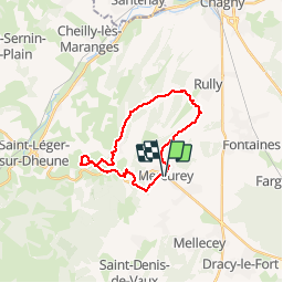

Length
20 km

Max alt
408 m

Uphill gradient
552 m
Km-Effort
27 km

Min alt
235 m

Downhill gradient
545 m
Boucle
Yes
Creation date :
2019-04-01 20:34:21.387
Updated on :
2019-04-01 20:34:21.441
1h53
Difficulty : Medium

FREE GPS app for hiking
 SityTrail
IGN / Geographical institutes
SityTrail Plus
The world is yours!
About
Trail Mountain bike of 20 km to be discovered at Bourgogne-Franche-Comté, Saône-et-Loire, Mercurey. This trail is proposed by XavierFaidix.
Positioning
Country:
France
Region :
Bourgogne-Franche-Comté
Department/Province :
Saône-et-Loire
Municipality :
Mercurey
Location:
Bourgneuf-Val-d'Or
Start:(Dec)
Start:(UTM)
630920 ; 5188431 (31T) N.
Comments