Pertes de lAin

Ajax44
User

Length
6.2 km

Max alt
707 m

Uphill gradient
203 m
Km-Effort
8.9 km

Min alt
536 m

Downhill gradient
205 m
Boucle
Yes
Creation date :
2017-09-01 00:00:00.0
Updated on :
2017-09-01 00:00:00.0
2h11
Difficulty : Medium

FREE GPS app for hiking
 SityTrail
IGN / Geographical institutes
SityTrail Plus
The world is yours!
About
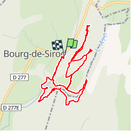
Trail Walking of 6.2 km to be discovered at Bourgogne-Franche-Comté, Jura, Bourg-de-Sirod. This trail is proposed by Ajax44.
Positioning
Country:
France
Region :
Bourgogne-Franche-Comté
Department/Province :
Jura
Municipality :
Bourg-de-Sirod
Location:
Unknown
Start:(Dec)
Start:(UTM)
726177 ; 5179216 (31T) N.
Comments