


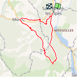
Saint André Moriez Courchons

pidjam
User

Length
16.3 km

Max alt
1355 m

Uphill gradient
668 m
Km-Effort
25 km

Min alt
881 m

Downhill gradient
669 m
Boucle
Yes
Creation date :
2018-04-16 22:23:20.635
Updated on :
2018-04-16 22:23:20.635
5h00
Difficulty : Medium

FREE GPS app for hiking
 SityTrail
IGN / Geographical institutes
SityTrail Plus
The world is yours!
About
Trail Walking of 16.3 km to be discovered at Provence-Alpes-Côte d'Azur, Alpes-de-Haute-Provence, Saint-André-les-Alpes. This trail is proposed by pidjam.
Description
Randonnée ST André-ruines de Courchons en commençant par un passage à Moriez (par col des Robines)
Positioning
Country:
France
Region :
Provence-Alpes-Côte d'Azur
Department/Province :
Alpes-de-Haute-Provence
Municipality :
Saint-André-les-Alpes
Location:
Unknown
Start:(Dec)
Start:(UTM)
300211 ; 4871289 (32T) N.
Comments