


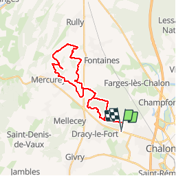
chatenoy-fontaines-mercurey

XavierFaidix
User

Length
28 km

Max alt
364 m

Uphill gradient
378 m
Km-Effort
33 km

Min alt
204 m

Downhill gradient
377 m
Boucle
Yes
Creation date :
2019-04-01 20:34:20.977
Updated on :
2019-04-01 20:34:21.05
2h44
Difficulty : Easy

FREE GPS app for hiking
 SityTrail
IGN / Geographical institutes
SityTrail Plus
The world is yours!
About
Trail Mountain bike of 28 km to be discovered at Bourgogne-Franche-Comté, Saône-et-Loire, Mellecey. This trail is proposed by XavierFaidix.
Positioning
Country:
France
Region :
Bourgogne-Franche-Comté
Department/Province :
Saône-et-Loire
Municipality :
Mellecey
Location:
Unknown
Start:(Dec)
Start:(UTM)
636596 ; 5184571 (31T) N.
Comments