


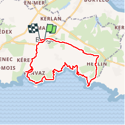
Bangor Pointe Saint Marc

patbt
User

Length
17.5 km

Max alt
55 m

Uphill gradient
324 m
Km-Effort
22 km

Min alt
0 m

Downhill gradient
330 m
Boucle
No
Creation date :
2018-04-16 22:34:17.491
Updated on :
2018-04-16 22:34:17.491
6h59
Difficulty : Medium

FREE GPS app for hiking
 SityTrail
IGN / Geographical institutes
SityTrail Plus
The world is yours!
About
Trail Walking of 17.5 km to be discovered at Brittany, Morbihan, Bangor. This trail is proposed by patbt.
Positioning
Country:
France
Region :
Brittany
Department/Province :
Morbihan
Municipality :
Bangor
Location:
Unknown
Start:(Dec)
Start:(UTM)
485670 ; 5240154 (30T) N.
Comments