


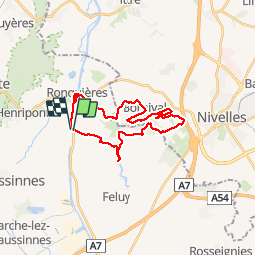
RONQUIÈRES CAF

reneperrin
User

Length
24 km

Max alt
132 m

Uphill gradient
287 m
Km-Effort
28 km

Min alt
52 m

Downhill gradient
282 m
Boucle
Yes
Creation date :
2018-04-16 22:39:56.808
Updated on :
2018-04-16 22:39:56.808
5h49
Difficulty : Easy

FREE GPS app for hiking
 SityTrail
IGN / Geographical institutes
SityTrail Plus
The world is yours!
About
Trail Walking of 24 km to be discovered at Wallonia, Hainaut, Braine-le-Comte. This trail is proposed by reneperrin.
Description
Boucle au départ du plan incliné de Ronquières
Photos


Positioning
Country:
Belgium
Region :
Wallonia
Department/Province :
Hainaut
Municipality :
Braine-le-Comte
Location:
Ronquières
Start:(Dec)
Start:(UTM)
586474 ; 5605123 (31U) N.
Comments