gres annot

bernir
User
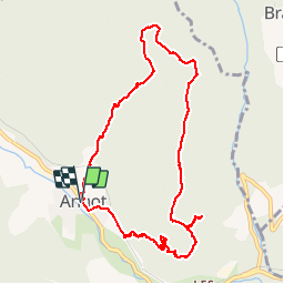

Length
10.7 km

Max alt
1191 m

Uphill gradient
660 m
Km-Effort
19.4 km

Min alt
689 m

Downhill gradient
658 m
Boucle
Yes
Creation date :
2018-04-16 22:55:32.349
Updated on :
2018-04-16 22:55:32.349
4h13
Difficulty : Medium

FREE GPS app for hiking
 SityTrail
IGN / Geographical institutes
SityTrail Plus
The world is yours!
About
Trail Walking of 10.7 km to be discovered at Provence-Alpes-Côte d'Azur, Alpes-de-Haute-Provence, Annot. This trail is proposed by bernir.
Positioning
Country:
France
Region :
Provence-Alpes-Côte d'Azur
Department/Province :
Alpes-de-Haute-Provence
Municipality :
Annot
Location:
Unknown
Start:(Dec)
Start:(UTM)
312867 ; 4870730 (32T) N.
Comments