


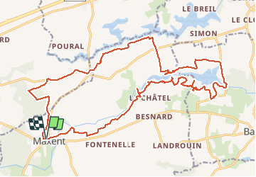
20.09.2017 - MAXENT EST

babeth35
User

Length
26 km

Max alt
130 m

Uphill gradient
305 m
Km-Effort
30 km

Min alt
83 m

Downhill gradient
306 m
Boucle
Yes
Creation date :
2017-09-20 00:00:00.0
Updated on :
2020-07-20 15:11:55.957
6h07
Difficulty : Easy

FREE GPS app for hiking
 SityTrail
IGN / Geographical institutes
SityTrail Plus
The world is yours!
About
Trail Walking of 26 km to be discovered at Brittany, Ille-et-Vilaine, Maxent. This trail is proposed by babeth35.
Positioning
Country:
France
Region :
Brittany
Department/Province :
Ille-et-Vilaine
Municipality :
Maxent
Location:
Unknown
Start:(Dec)
Start:(UTM)
572087 ; 5314848 (30T) N.
Comments