


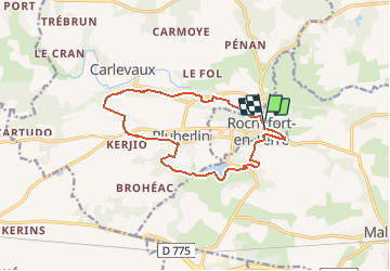
Rochefort-en-Terre 2

cron
User

Length
13.1 km

Max alt
87 m

Uphill gradient
187 m
Km-Effort
15.6 km

Min alt
27 m

Downhill gradient
190 m
Boucle
Yes
Creation date :
2017-09-20 00:00:00.0
Updated on :
2017-09-20 00:00:00.0
3h23
Difficulty : Easy

FREE GPS app for hiking
 SityTrail
IGN / Geographical institutes
SityTrail Plus
The world is yours!
About
Trail Walking of 13.1 km to be discovered at Brittany, Morbihan, Rochefort-en-Terre. This trail is proposed by cron.
Positioning
Country:
France
Region :
Brittany
Department/Province :
Morbihan
Municipality :
Rochefort-en-Terre
Location:
Unknown
Start:(Dec)
Start:(UTM)
549756 ; 5283098 (30T) N.
Comments