


m'ont todun

marchev
User
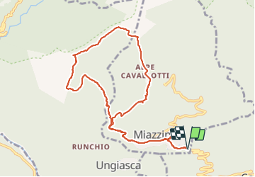

Length
10.9 km

Max alt
1303 m

Uphill gradient
691 m
Km-Effort
20 km

Min alt
669 m

Downhill gradient
690 m
Boucle
Yes
Creation date :
2018-04-16 23:15:48.019
Updated on :
2018-04-16 23:15:48.019
6h32
Difficulty : Medium

FREE GPS app for hiking
 SityTrail
IGN / Geographical institutes
SityTrail Plus
The world is yours!
About
Trail Walking of 10.9 km to be discovered at Piemont, Verbano-Cusio-Ossola, Miazzina. This trail is proposed by marchev.
Photos


30 photos in total. Please click on a photo to see them all in the gallery.
Positioning
Country:
Italy
Region :
Piemont
Department/Province :
Verbano-Cusio-Ossola
Municipality :
Miazzina
Location:
Unknown
Start:(Dec)
Start:(UTM)
463598 ; 5091247 (32T) N.
Comments