


SILLANS

gallo
User

Length
9.7 km

Max alt
601 m

Uphill gradient
292 m
Km-Effort
13.6 km

Min alt
400 m

Downhill gradient
291 m
Boucle
Yes
Creation date :
2018-04-16 23:16:37.199
Updated on :
2018-04-16 23:16:37.199
4h00
Difficulty : Easy

FREE GPS app for hiking
 SityTrail
IGN / Geographical institutes
SityTrail Plus
The world is yours!
About
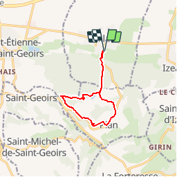
Trail Walking of 9.7 km to be discovered at Auvergne-Rhône-Alpes, Isère, Sillans. This trail is proposed by gallo.
Description
Chateau de Sillans, les étangs
Positioning
Country:
France
Region :
Auvergne-Rhône-Alpes
Department/Province :
Isère
Municipality :
Sillans
Location:
Unknown
Start:(Dec)
Start:(UTM)
687301 ; 5023326 (31T) N.
Comments