


vienne en val - tigy

michelleverdier
User
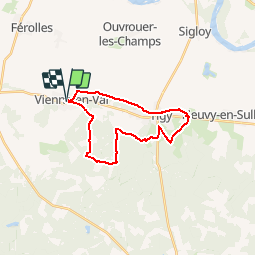

Length
21 km

Max alt
150 m

Uphill gradient
167 m
Km-Effort
23 km

Min alt
99 m

Downhill gradient
166 m
Boucle
Yes
Creation date :
2018-04-16 23:18:10.69
Updated on :
2018-04-16 23:18:10.69
5h02
Difficulty : Easy

FREE GPS app for hiking
 SityTrail
IGN / Geographical institutes
SityTrail Plus
The world is yours!
About
Trail Walking of 21 km to be discovered at Centre-Loire Valley, Loiret, Vienne-en-Val. This trail is proposed by michelleverdier.
Positioning
Country:
France
Region :
Centre-Loire Valley
Department/Province :
Loiret
Municipality :
Vienne-en-Val
Location:
Unknown
Start:(Dec)
Start:(UTM)
435254 ; 5294541 (31T) N.
Comments