


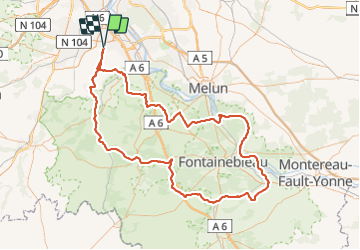
2017-09-24 Bondoufle-Moret sur Loing et retour

Lucquiaud
User

Length
143 km

Max alt
145 m

Uphill gradient
1089 m
Km-Effort
157 km

Min alt
39 m

Downhill gradient
1087 m
Boucle
Yes
Creation date :
2018-09-15 15:03:22.273
Updated on :
2018-09-15 15:03:22.357
8h56
Difficulty : Medium

FREE GPS app for hiking
 SityTrail
IGN / Geographical institutes
SityTrail Plus
The world is yours!
About
Trail Cycle of 143 km to be discovered at Ile-de-France, Essonne, Bondoufle. This trail is proposed by Lucquiaud.
Positioning
Country:
France
Region :
Ile-de-France
Department/Province :
Essonne
Municipality :
Bondoufle
Location:
Unknown
Start:(Dec)
Start:(UTM)
454025 ; 5384740 (31U) N.
Comments