


MONTLOGNON MN

dartoisclaude
User
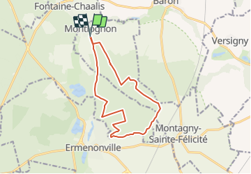

Length
12.3 km

Max alt
132 m

Uphill gradient
154 m
Km-Effort
14.4 km

Min alt
70 m

Downhill gradient
154 m
Boucle
Yes
Creation date :
2018-04-16 23:29:23.732
Updated on :
2018-04-16 23:29:23.732
2h00
Difficulty : Very difficult

FREE GPS app for hiking
 SityTrail
IGN / Geographical institutes
SityTrail Plus
The world is yours!
About
Trail Nordic walking of 12.3 km to be discovered at Hauts-de-France, Oise, Montlognon. This trail is proposed by dartoisclaude.
Description
Parcours nordique
Positioning
Country:
France
Region :
Hauts-de-France
Department/Province :
Oise
Municipality :
Montlognon
Location:
Unknown
Start:(Dec)
Start:(UTM)
477723 ; 5445467 (31U) N.
Comments