


-- callelongue - samena - col de la selle - calanque de marseilleveyre .gpx

georgein
User

Length
10.8 km

Max alt
263 m

Uphill gradient
536 m
Km-Effort
17.9 km

Min alt
3 m

Downhill gradient
534 m
Boucle
Yes
Creation date :
2019-08-04 09:21:13.162
Updated on :
2020-01-31 20:31:03.521
--
Difficulty : Unknown

FREE GPS app for hiking
 SityTrail
IGN / Geographical institutes
SityTrail Plus
The world is yours!
About
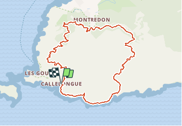
Trail Walking of 10.8 km to be discovered at Provence-Alpes-Côte d'Azur, Bouches-du-Rhône, Marseille. This trail is proposed by georgein.
Positioning
Country:
France
Region :
Provence-Alpes-Côte d'Azur
Department/Province :
Bouches-du-Rhône
Municipality :
Marseille
Location:
8th Arrondissement
Start:(Dec)
Start:(UTM)
691229 ; 4787119 (31T) N.
Comments