


2017-10-12 Rando CVA Vosges Climont Aubure

holtzv
User GUIDE
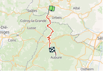

Length
28 km

Max alt
924 m

Uphill gradient
1269 m
Km-Effort
44 km

Min alt
360 m

Downhill gradient
1142 m
Boucle
No
Creation date :
2018-04-16 23:42:36.154
Updated on :
2018-04-16 23:42:36.154
5h19
Difficulty : Medium

FREE GPS app for hiking
 SityTrail
IGN / Geographical institutes
SityTrail Plus
The world is yours!
About
Trail Equestrian of 28 km to be discovered at Grand Est, Bas-Rhin, Urbeis. This trail is proposed by holtzv.
Positioning
Country:
France
Region :
Grand Est
Department/Province :
Bas-Rhin
Municipality :
Urbeis
Location:
Unknown
Start:(Dec)
Start:(UTM)
365298 ; 5355013 (32U) N.
Comments