


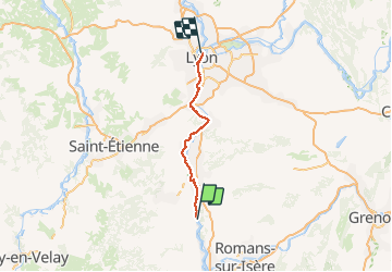
Vélo TP 6 st Vallier lyon

manginpascale
User

Length
92 km

Max alt
202 m

Uphill gradient
711 m
Km-Effort
101 km

Min alt
126 m

Downhill gradient
659 m
Boucle
No
Creation date :
2018-04-16 23:44:13.512
Updated on :
2018-04-16 23:44:13.512
7h19
Difficulty : Unknown

FREE GPS app for hiking
 SityTrail
IGN / Geographical institutes
SityTrail Plus
The world is yours!
About
Trail Cycle of 92 km to be discovered at Auvergne-Rhône-Alpes, Drôme, Saint-Vallier. This trail is proposed by manginpascale.
Positioning
Country:
France
Region :
Auvergne-Rhône-Alpes
Department/Province :
Drôme
Municipality :
Saint-Vallier
Location:
Unknown
Start:(Dec)
Start:(UTM)
642528 ; 5004712 (31T) N.
Comments