


brame

barney06
User
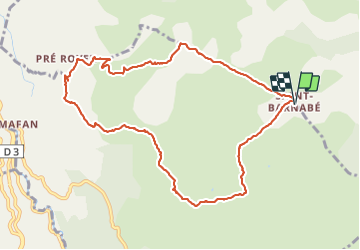

Length
10.8 km

Max alt
1025 m

Uphill gradient
244 m
Km-Effort
14 km

Min alt
853 m

Downhill gradient
244 m
Boucle
Yes
Creation date :
2018-04-16 23:50:13.635
Updated on :
2018-04-16 23:50:13.635
7h07
Difficulty : Easy

FREE GPS app for hiking
 SityTrail
IGN / Geographical institutes
SityTrail Plus
The world is yours!
About
Trail Walking of 10.8 km to be discovered at Provence-Alpes-Côte d'Azur, Maritime Alps, Courmes. This trail is proposed by barney06.
Description
tando
Positioning
Country:
France
Region :
Provence-Alpes-Côte d'Azur
Department/Province :
Maritime Alps
Municipality :
Courmes
Location:
Unknown
Start:(Dec)
Start:(UTM)
342119 ; 4847520 (32T) N.
Comments