


Luberon - Mérindol (boucle)

uru2010
User

Length
11.8 km

Max alt
333 m

Uphill gradient
329 m
Km-Effort
16.2 km

Min alt
169 m

Downhill gradient
331 m
Boucle
Yes
Creation date :
2018-04-16 23:50:44.169
Updated on :
2018-04-16 23:50:44.169
4h01
Difficulty : Easy

FREE GPS app for hiking
 SityTrail
IGN / Geographical institutes
SityTrail Plus
The world is yours!
About
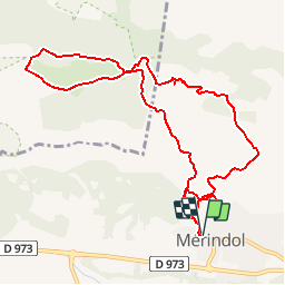
Trail Walking of 11.8 km to be discovered at Provence-Alpes-Côte d'Azur, Vaucluse, Mérindol. This trail is proposed by uru2010.
Description
Boucle depuis Mérindol vers Fond de l'Orme.
Positioning
Country:
France
Region :
Provence-Alpes-Côte d'Azur
Department/Province :
Vaucluse
Municipality :
Mérindol
Location:
Unknown
Start:(Dec)
Start:(UTM)
677216 ; 4847162 (31T) N.
Comments