


2017-10-01.gpx

georgein
User
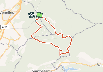

Length
14.3 km

Max alt
511 m

Uphill gradient
335 m
Km-Effort
18.8 km

Min alt
308 m

Downhill gradient
339 m
Boucle
Yes
Creation date :
2019-08-04 09:21:12.725
Updated on :
2020-01-31 20:31:02.856
--
Difficulty : Unknown

FREE GPS app for hiking
 SityTrail
IGN / Geographical institutes
SityTrail Plus
The world is yours!
About
Trail Walking of 14.3 km to be discovered at Provence-Alpes-Côte d'Azur, Bouches-du-Rhône, Venelles. This trail is proposed by georgein.
Positioning
Country:
France
Region :
Provence-Alpes-Côte d'Azur
Department/Province :
Bouches-du-Rhône
Municipality :
Venelles
Location:
Unknown
Start:(Dec)
Start:(UTM)
703054 ; 4829680 (31T) N.
Comments