


2017-10-08.gpx

georgein
User
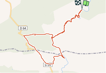

Length
11.2 km

Max alt
449 m

Uphill gradient
237 m
Km-Effort
14.3 km

Min alt
276 m

Downhill gradient
243 m
Boucle
Yes
Creation date :
2019-08-04 09:21:07.767
Updated on :
2020-01-31 20:30:56.851
--
Difficulty : Unknown

FREE GPS app for hiking
 SityTrail
IGN / Geographical institutes
SityTrail Plus
The world is yours!
About
Trail Walking of 11.2 km to be discovered at Provence-Alpes-Côte d'Azur, Var, Tourves. This trail is proposed by georgein.
Positioning
Country:
France
Region :
Provence-Alpes-Côte d'Azur
Department/Province :
Var
Municipality :
Tourves
Location:
Unknown
Start:(Dec)
Start:(UTM)
737438 ; 4808288 (31T) N.
Comments